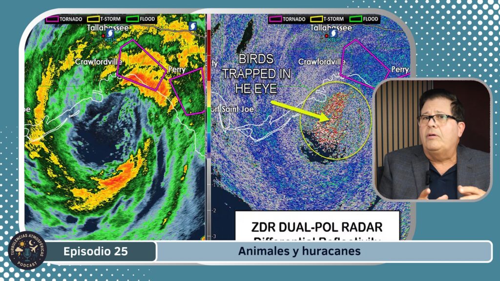

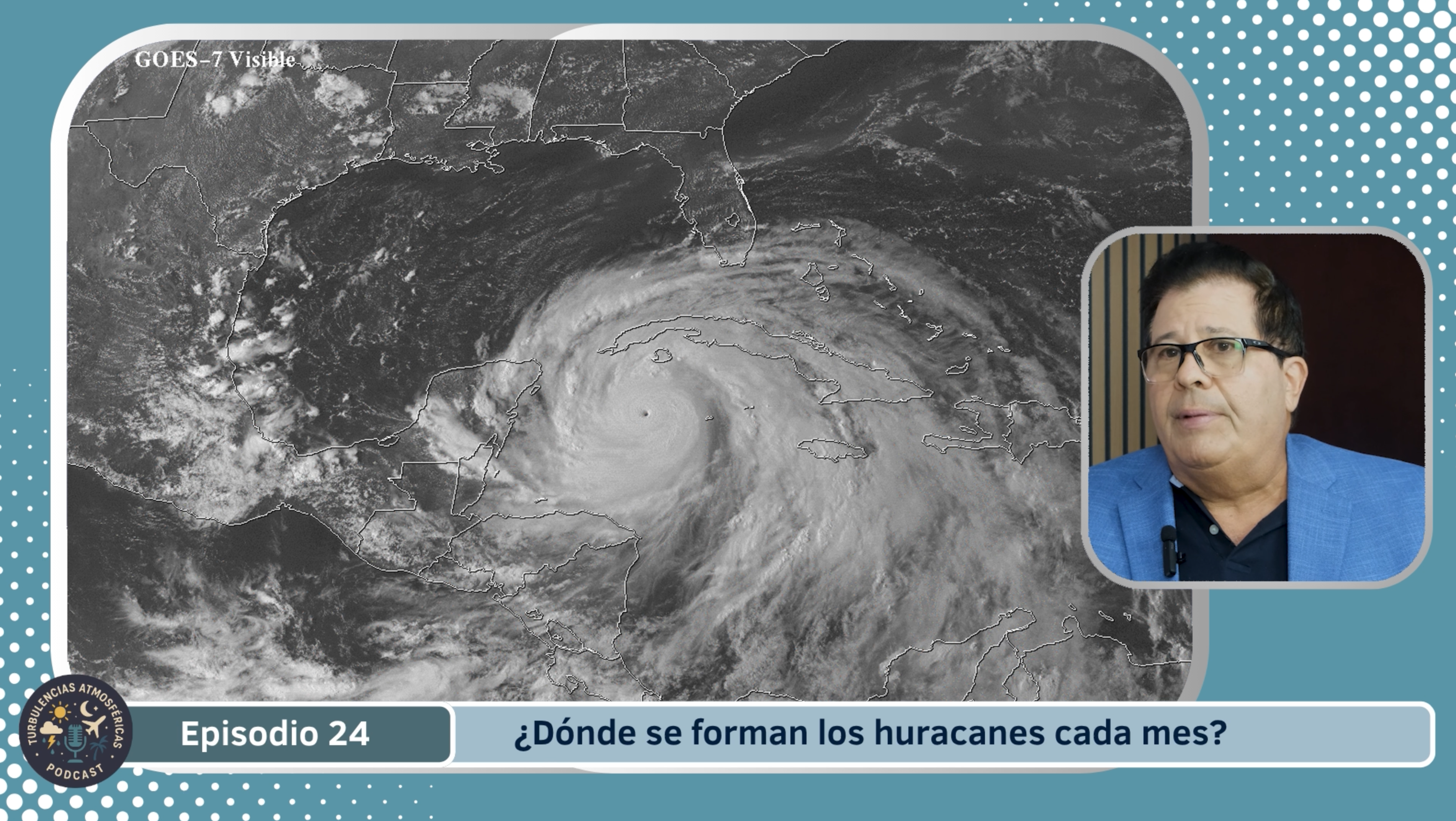
Cada año, el Atlántico tropical se convierte en el escenario de una de las fuerzas más poderosas de la naturaleza: los huracanes. Pero ¿sabías que no se forman en cualquier momento ni en cualquier lugar? La temporada de huracanes sigue un patrón muy claro, que depende del calentamiento progresivo del océano, los vientos dominantes y la posición de las ondas tropicales que viajan desde África hacia América. A lo largo de los meses de junio a noviembre, los científicos del National Hurricane Center (NHC) observan cómo cambia la probabilidad de formación, desplazándose desde el Golfo de México y el Caribe hasta el Atlántico central.
Junio
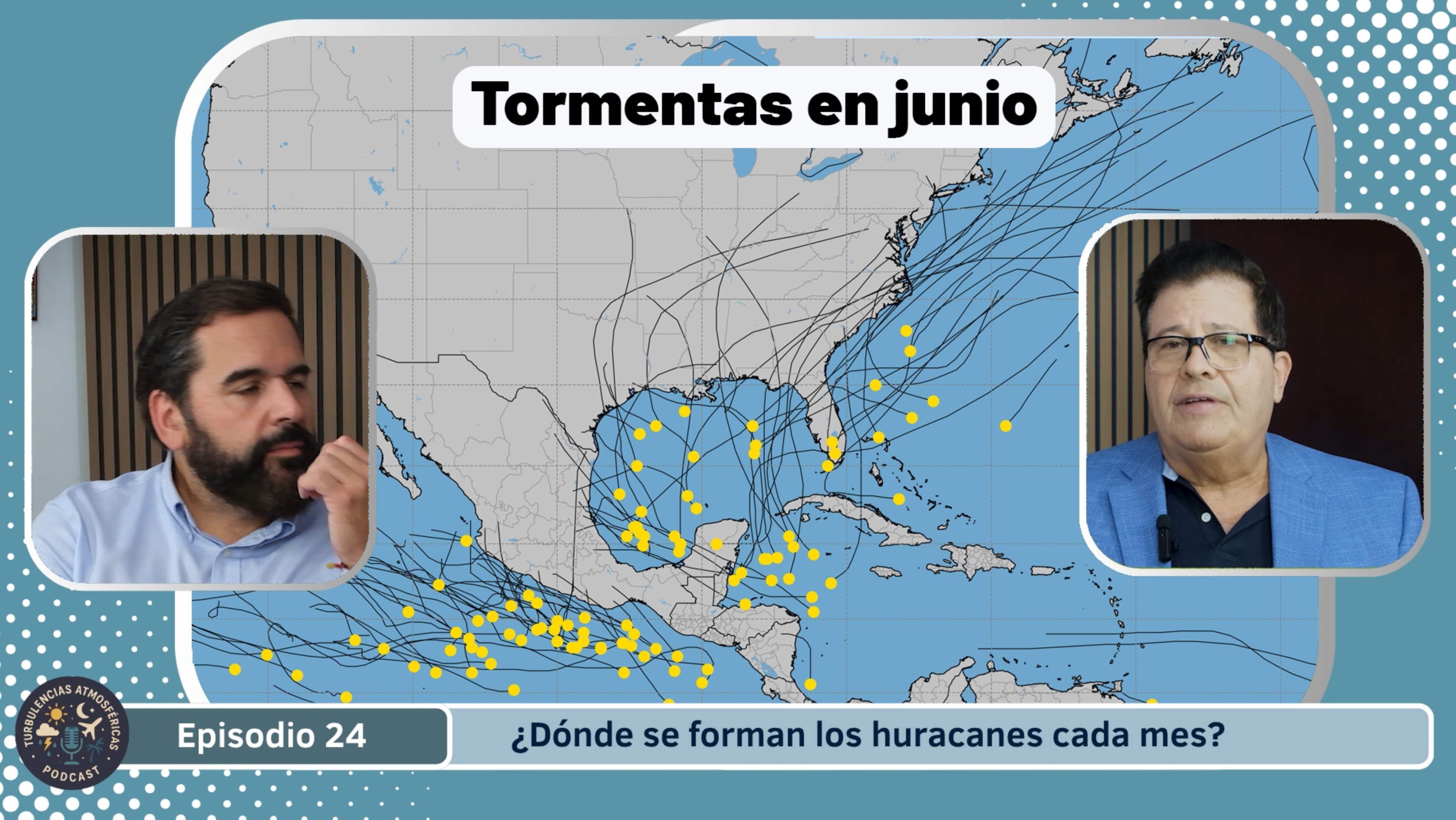
La temporada oficial de huracanes en el Atlántico comienza el 1 de junio y se extiende hasta el 30 de noviembre. En junio, aún se están estableciendo las condiciones favorables: las aguas tropicales del Atlántico y del Caribe comienzan a calentarse, pero la cizalladura del viento (cambios de velocidad o dirección con altura) aún suele ser relativamente alta y estabiliza la atmósfera. Por ello, los ciclones tropicales que se forman en junio suelen tener origen en el Mar Caribe occidental o en el Golfo de México, con trayectorias menos alargadas hacia el Atlántico abierto. Aun así, es importante estar preparado desde este mes, porque aunque la actividad es moderada, cualquier sistema que se organice puede evolucionar.
Julio
En julio la actividad va en aumento. Las aguas están más cálidas, las perturbaciones tropicales que vienen de África (ondas tropicales) comienzan a tener más “combustible” para desarrollarse, y la cizalladura tiende a disminuir en algunas zonas. El origen de la mayoría de los ciclones en esta época se traslada hacia el este del Caribe y las Antillas Menores, avanzando potencialmente hacia el norte o noroeste. Si bien no se alcanza todavía el nivel máximo de actividad, julio marca la entrada en el período más activo.
Agosto
Agosto es cuando la temporada “despega” de verdad. Según climatología, entre agosto y principios de octubre se produce la mayor parte de los huracanes. Las aguas del Atlántico abierto (la “Main Development Region”, MDR, entre África y el Caribe) alcanzan sus temperaturas máximas, la cizalladura disminuye, y las ondas tropicales viajan más directo hacia esas aguas cálidas, lo que facilita la formación de tormentas tropicales que pueden intensificarse. En esta etapa los sistemas pueden formarse más lejos al este y luego moverse hacia el Caribe, Golfo de México, o ascender hacia la costa este de EE.UU. o Canadá.
Septiembre
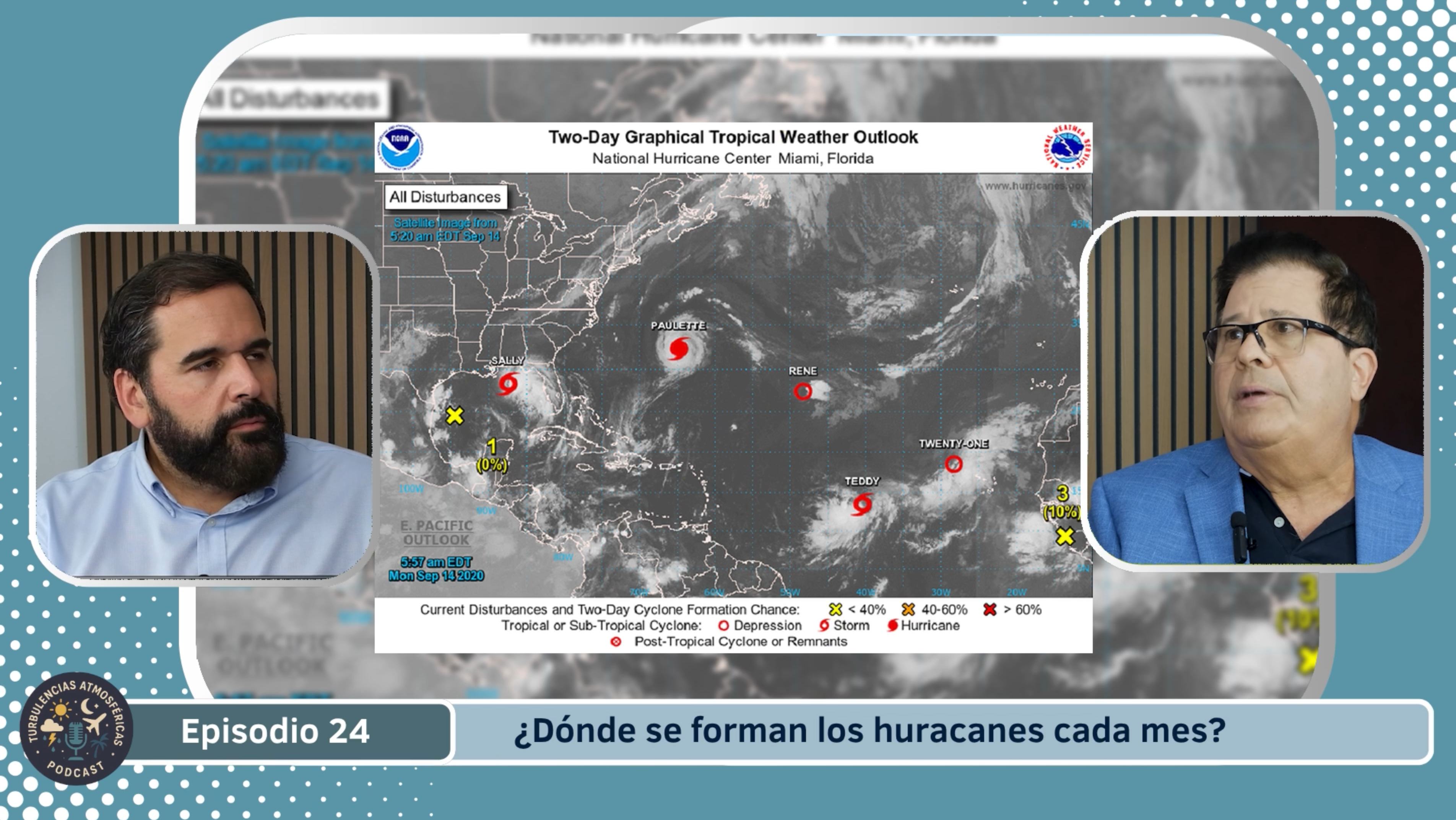
En septiembre se alcanza el pico climatológico de la temporada. Históricamente, el 10 de septiembre es el día en que más actividad (en términos de tormentas nombradas) se registra en la cuenca atlántica. Durante este mes se combinan todos los factores: aguas muy cálidas, cizalladura baja, humedad elevada, y perturbaciones abundantes. La formación ocurre tanto en el Atlántico abierto como en el Caribe y el Golfo, y los huracanes pueden alcanzar gran intensidad. Tras este pico, la actividad comienza a disminuir, pero sigue alta al menos hasta octubre.
Octubre
En octubre la actividad sigue siendo relevante, pero ya se observa un desplazamiento del origen de los huracanes hacia el Caribe y el Golfo de México más que hacia el Atlántico abierto. Las aguas aún están calientes, pero la cizalladura tiende a aumentar gradualmente y las condiciones son menos ideales que en agosto-septiembre. Aun así, pueden formarse huracanes fuertes, incluso hasta finales del mes. Se habla también de un “segundo pico” menor alrededor de mediados de octubre.
Noviembre
Noviembre marca el cierre de la temporada. Aunque la mayoría de los huracanes ya han ocurrido, el riesgo no desaparece hasta que la temporada termina el 30 de noviembre. En este tiempo el número de formaciones desciende significativamente, las aguas se enfrían, la cizalladura crece y la atmósfera se estabiliza, lo que reduce la frecuencia de ciclones. Pero sistemas ocasionales pueden formarse aún, especialmente en el Caribe occidental o el Golfo de México.
Puedes escuchar más episodios de nuestro pódcast “Turbulencias Atmosféricas” y seguir toda la cobertura del tiempo y el clima en Canal Meteo TV. Encuéntranos en canalmeteo.tv, en YouTube y en todas las plataformas de audio. ¡No te pierdas los próximos capítulos y mantente informado con Canal Meteo!