


What was already a dangerous and deadly tropical storm strengthened on Saturday to become a category 2 hurricane, and the forecasts have become even more serious in the face of the potentially catastrophic impacts that could be felt in Jamaica, Haiti, Dominican Republic and even Cuba, The system is expected to be rapidly intensify into a major hurricane on Sunday.
Melissa has already been paid at least three lives in the Dominican Republic at the beginning of the week, after remaining almost stationary over the Caribbean, leaving rain accumulations of several centimeters. In Haiti, the Civil Protection Agency confirmed a landslide in Fontamara (Port-au-Prince) which resulted in two fatalities, while a man lost his life in Marigot when a tree fell during the floods.
Now, the hurricane sets its sights on Jamaica, where the latest forecasts of the National Hurricane Center (NHC) warn of a possible worst case scenarioa storm that could rapidly intensify to a major category before hitting the southern coast of the island at a minimum travel speed, causing days of torrential rains, destructive gusts and life-threatening storm surges.
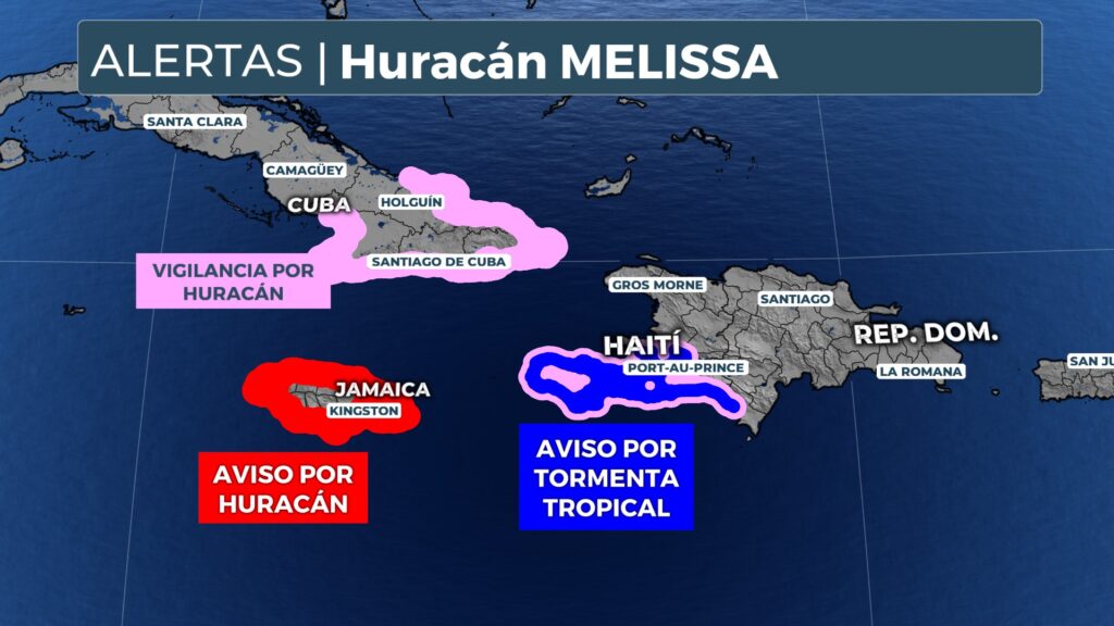
Currently governed by hurricane warnings for all of Jamaica, y surveillance for the southwestern part of Haiti and the Cuban provinces of Granma, Santiago de Cuba, Guantánamo and Holguín. The system barely advances to 3 miles per hour (5 km/h) and is expected to move slowly westward over the weekend, before turning north towards Jamaica between Monday and Tuesday.
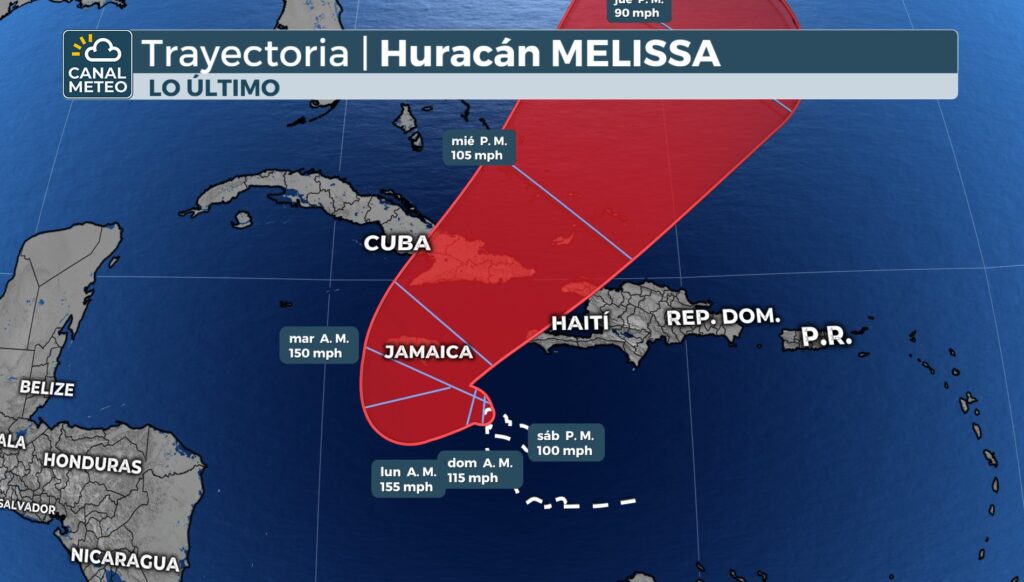
The NHC warned that Melissa could make landfall in Jamaica in about 72 hours, possibly on Tuesday. The most worrisome is that the island will experience several days of heavy rains and tropical storm force winds before the hurricane's core arrives, which contains the strongest winds.
Forecast models indicate that Melissa could escalate rapidly, increasing by more than 60 miles per hour in just two dayswith maximum winds up to 160 mph (260 km/h) near the Jamaican coast, which would place it on the brink of the category 5.
The authorities warn that Jamaica could face a protracted and devastating impact, unprecedented in modern times. The waters to the south of the country are abnormally warm, and the atmospheric conditions favor a explosive strengthening. The consensus of the models shows a extreme threat to the Kingston metropolitan area due to rains, winds and storm surge.
The National Hurricane Center also used unusually forceful language in highlighting the magnitude of the danger:
“Melissa's slow travel will bring a period of several days with damaging winds and heavy rain, likely causing catastrophic flash flooding, landslides, extensive structural damage, prolonged power and communications outages, and isolation of communities."
The government of Jamaica activated the national emergency center and deployed generators, fuel and medical supplies before the arrival of the hurricane.
“We have more than 50 generators ready to restore drinking water to 80% of users in the first 72 hours after the passage of the system,” the Minister of Water, Environment and Climate Change said, Matthew Samuda.
The Kingston airport will close operations as of 9 p.m. on Saturday. Due to its location on an open peninsula to the south, there is risk of storm surge of up to 10 feet (3 meters) above the usual high tide level, This could cause significant damage to coastal infrastructure.
The Jamaica Meteorological Service also warned that the soils are already saturated by previous rains, which increases the risk of landslides as Melissa approaches.
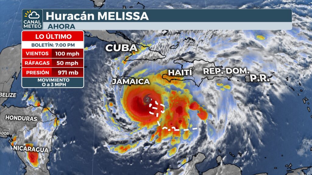
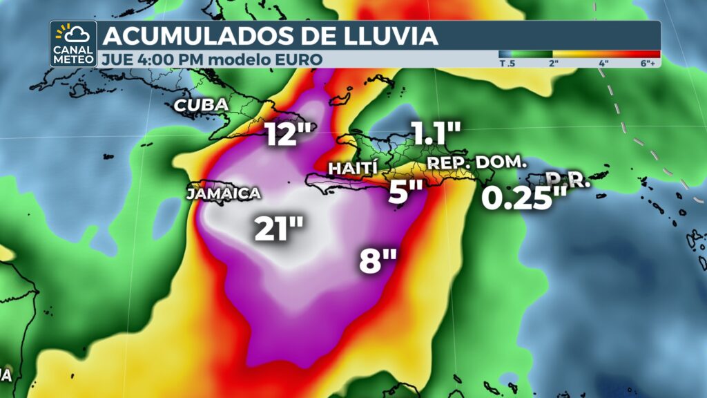
Melissa is currently at about 210 km southeast of Kingstonwith sustained winds of 160 km/h. Forecasts warn of catastrophic floods as the hurricane unloads rainfall over several days: the accumulated 15 to 25 inches (380-630 mm) in Jamaica until Tuesday, with up to 35 inches (900 mm)in areas of Haiti.
In Cuba, there could be between 4 and 8 inches (100-200 mm), with isolated highs of 12 inches (300 mm) as Melissa moves eastward across the island by midweek.
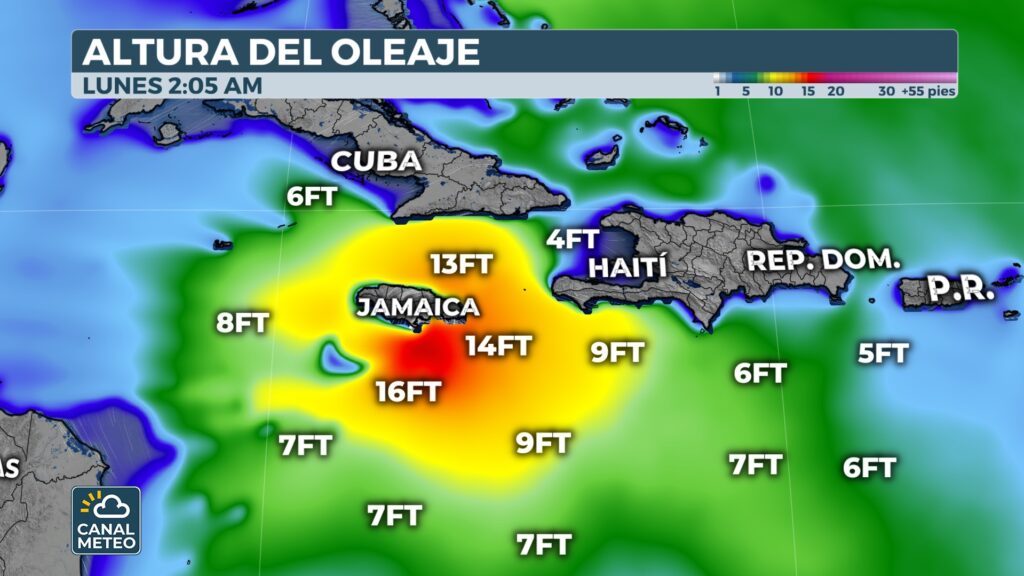
In addition, the wide wind field and the slowness of the system will generate a powerful storm surge which could reach between 7 and 11 feet (2-3.5 meters) above ground level, accompanied by large and destructive waves.
The tropical storm conditions will begin to be felt in Jamaica from Saturday night onwards, while the hurricane conditions will arrive between Sunday and Monday.
After crossing Jamaica, Melissa could make landfall again on Cuba's eastern coast on Wednesday, possibly still as a major hurricane, before affecting the Turks and Caicos Islands and subsequently the Eastern Bahamas, on the way to the open Atlantic.
This way you can see Weather Channel


