
This week, a large area of high pressureknown as "heat dome"The storm is strengthening over the central United States, extending eastward across the country.
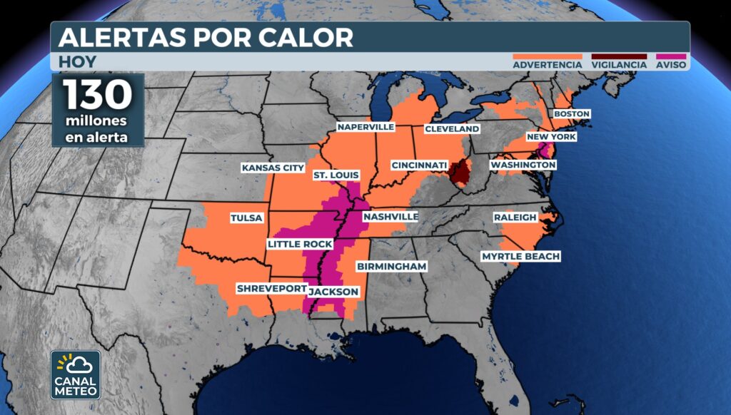
More of 129 million people more than 20 states are under extreme heat alerts, from the South to the East Coast. A large heat dome - a dome of high pressure that acts like a lid on the atmosphere - is trapping hot, dry air, causing sweltering and dangerous temperatures.
In some areas, the wind chill exceeds 100 °F (38 °C)and the heat is expected to reach almost 200 million people before the weekend.
More than two dozen cities are recording one of the five hottest summers on record, with temperatures between 1 and 3 degrees above average.
Long-term forecasts point to a higher East and Northeast U.S. will continue with temperatures higher than normal for the remainder of the summer.
💥 Attention in cities such as New York or Philadelphia, where new records could be set.
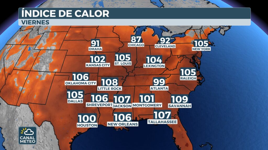
The most difficult part will not only be the heat, but also the humidityThis will significantly increase the heat index or "real" temperature. In cities such as St. Louis, Kansas City or Oklahoma CityThe wind chill is expected to exceed 100 °F (38 °C)and at some points it could even come close to 110-115 °F (43-46 °C).
This level of humidity prevents the body from being adequately cooled by perspiration, making the heat feel much hotter than the thermometer shows.
Under the dome, the weather will remain mostly dryas in the case of Texaswhere a week without rain is expected, a respite after recent flooding in areas such as Kerrville.
However, the moisture that cannot ascend inside the dome is forced to border the domegenerating unstable conditions along its boundaries. This results in the development of severe storms in what is known as the "ring of fire" of the heat dome.
These storms can produce:
- Damaging winds
- Large hail
- Heavy rains which, if repeated over the same areas, can cause flash floodingespecially in regions that have already been affected recently.
The areas with the highest risk at the beginning of the week include the Midwestthe Tennessee River Valley and parts of the southeast.
As the week progresses, the dome will move eastward. This will temporarily reduce thunderstorms in some locations, but will the heat will continue.
By Thursday, areas of the Great Lakes will have thermal sensations in the 90 °F (32-35 °C)and already on Friday, the worst of the heat will move towards the I-95 corridoraffecting cities such as Washington, New York and Bostonwith highs also in the 90s.
With a tropical air mass overhead, the wind chill will easily exceed 100 °F (38 °C) in the afternoon. Some records could even be broken, for example, at Newark (New Jersey)where temperatures are expected to be close to 90s.
Towards the weekend, cities such as New York and Boston could experience a slight decrease, with highs returning to the 80s, but the east-central will continue under very hot conditions.
Long-term models keep the East and northeast of the country with above average temperatures for the rest of the summer.
📲 Follow Weather Channel for more updates on this heat wave and possible severe storms.


