


Current weather models indicate that a fast-moving snowstorm will arrive in the Midwest on Saturday and move into the Mid-Atlantic and Northeast on Sunday. The speed of the system could limit snow accumulations along the I-95 corridor, and there is still uncertainty about the exact path of the heaviest snowfall.
The circulation of the Polar Vortex will weaken over the weekend, allowing more cold air to descend into the Midwest and Northeast.
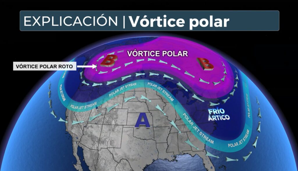
WHAT IS THE POLAR VORTEX?
The Polar Vortex is a large persistent area of low pressure and very cold air located near the poles, between 10 and 30 miles above the Earth's surface. When it is strong, it keeps the coldest air confined to the Arctic regions; when it weakens, it allows that frigid air to descend to lower levels of the atmosphere, accompanied by ripples in the Pacific jet stream that push that air from Canada into the continental United States.
Arctic air will create ideal conditions for snow formation in this fast-moving system moving from the northwest to the east.
Forecast models show increased agreement that snow will affect the Midwest and Ohio Valley on Saturday. Cities such as Indianapolis, Cincinnati and Columbus will see snow again Saturday night, following Thursday and Friday's episode.
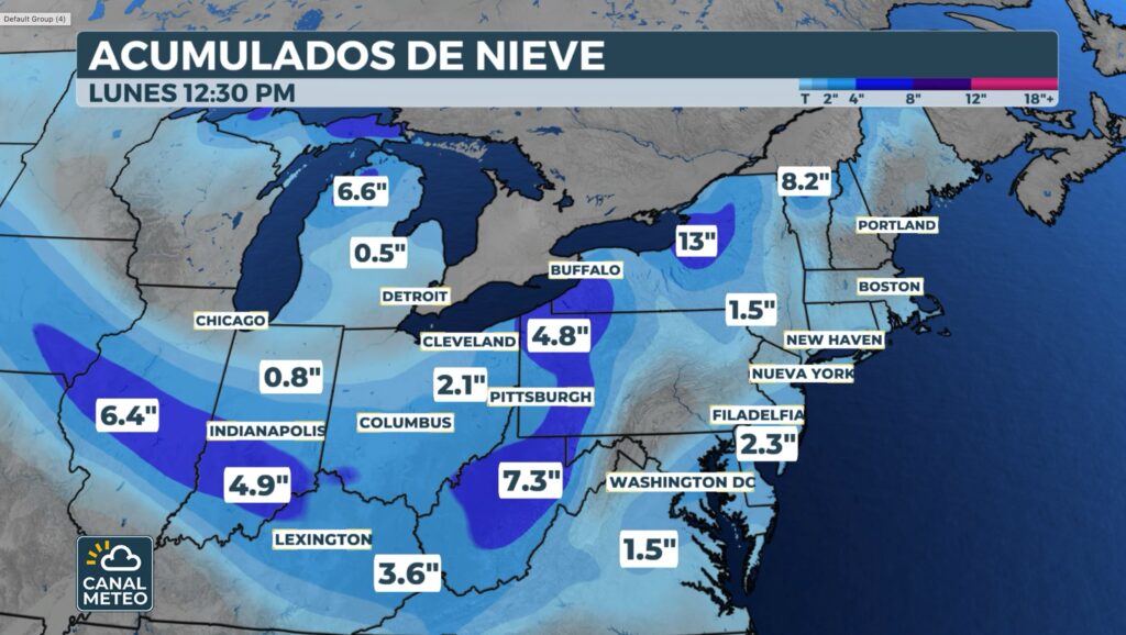
Snow will reach the Northeast during the early hours of Sunday morning, with many coastal areas waking up under a blanket of white before the system quickly moves away in the early afternoon.
See expect accumulations general 1 to 3 inches from Indiana and Ohio to Maryland, New Jersey and parts of southern New England. Areas of Indiana and Ohio could experience locally accumulations of 3 to 5 inches.
There is still uncertainty about the exact path of the system on Sunday:
- One more path north would increase snow for Boston and southern New England.
- One more path south would concentrate the heaviest snowfall in Philadelphia and southern New Jersey.
Regardless of the route, it is expected that it will be the first significant snowfall of the season for the Boston, New York and Philadelphia metropolitan areas.
Those with outdoor plans are advised to stay informed as the forecast adjusts.
This new system is consistent with the long-term outlook released by NOAA, which anticipated an active onset of winter weather, influenced in part by the weather pattern of La Niña.


