


A devastating series of floods swept through Central Texas on Friday, July 4, 2025, leaving a tragic toll of at least 68 dead and more than 800 people rescued. Amid the grief and shock, many are wondering if there were sufficient advance warnings to prevent the tragedy.
Important points
- Timeline: alerts before the tragedy
- Tuesday, July 1 - First signs
- Thursday, July 3 - Growing Concern
- Friday, July 4th - The most critical dawn
- 1:14 a.m. - First official Flash Flood Warning
- 2:28 a.m. - Critical conditions report
- 3:02 a.m. - The event becomes dangerous
- 4:03 a.m. - Flash Flood Emergency Declared
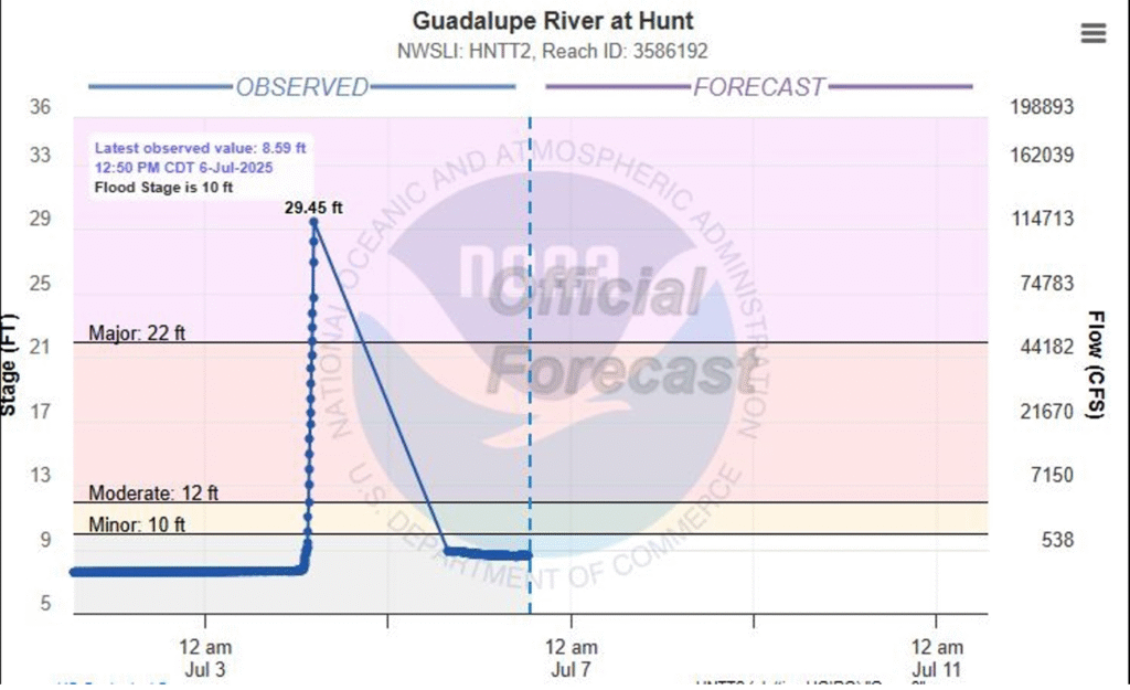
- 4:20 a.m. - Guadalupe River reaches major flood level
- What went wrong?
- Conclusion
In Canal Meteo we review chronologically the warnings issued by the National Weather Service (NWS) to understand how the event evolved.
Timeline: alerts before the tragedy
Tuesday, July 1 - First signs
As of Tuesday, the NWS offices at Austin and San Antonio began to warn of the potential for heavy rains and river flooding. Although the situation was not yet critical, meteorologists were already anticipating a possible significant flooding event.
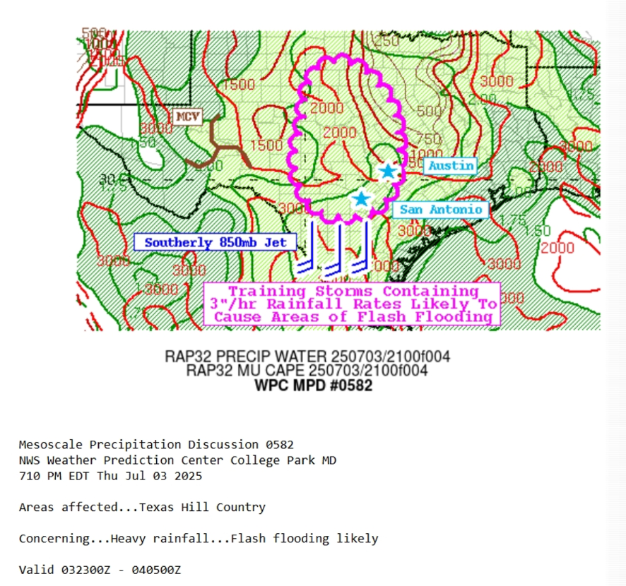
Thursday, July 3 - Growing Concern
On Thursday, the language of forecasts changed. Specialists were already talking about heavy rains capable of causing flash floods and rapid rises in river levels.
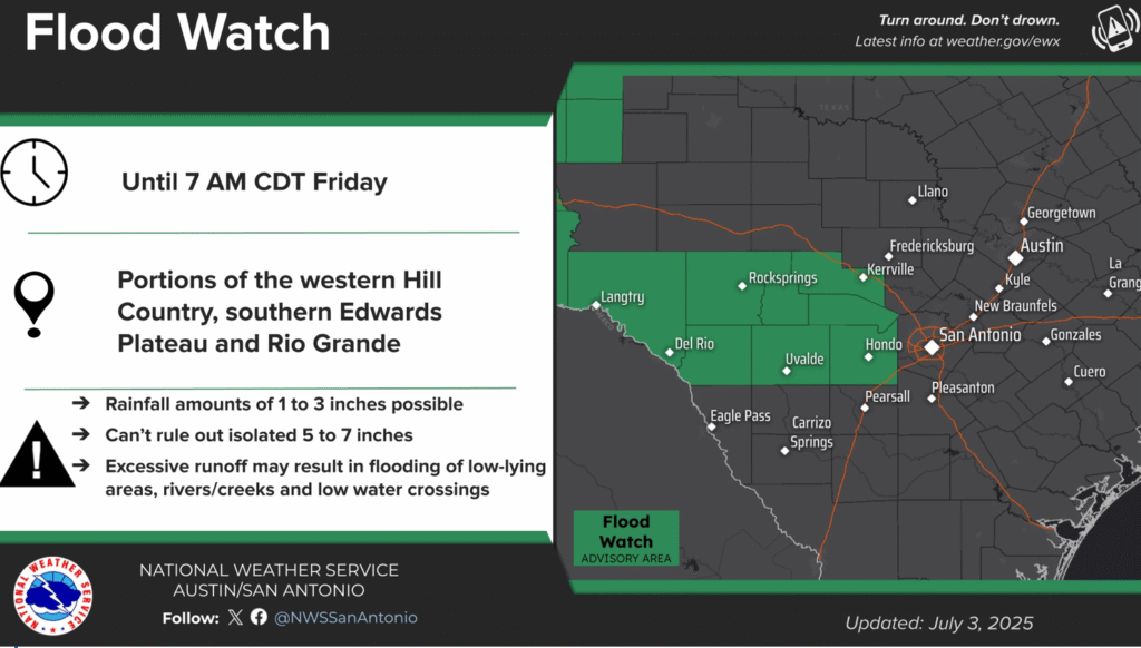
- 1:18 p.m. - A Flood Watch is issued.Includes the Kerr Countywarning of the possibility of rainfall accumulations of up to 7 inches (≈ 180 mm). Not an imminent warning, but a serious warning.
- 6:10 p.m. - Special Weather DiscussionA rare advisory in which the NWS talked about:
- "Worrying trends"
- "Heavy rains that could exceed 3 inches per hour."
- "High probability of flash floods"
Friday, July 4th - The most critical dawn
1:14 a.m. - First official Flash Flood Warning
Issued for Kerr County with the label "Considerable."This indicates that the threat is significant and potentially life-threatening. This type of warning automatically activates the wireless alerts (WEA) in cell phones.
However, it is still unclear whether residents in the affected areas received the warning in time. There are reports of areas with limited cellular coverage, which could have compromised the effectiveness of the message.

2:28 a.m. - Critical conditions report
In an internal NWS chat, meteorologists indicated that. up to 5 inches of rain had already fallenand that the flood was already happening in Kerr County.
3:02 a.m. - The event becomes dangerous
It is described as a "dangerous flash flood event in southern Kerr County." At that time, conditions were already extremely serious.
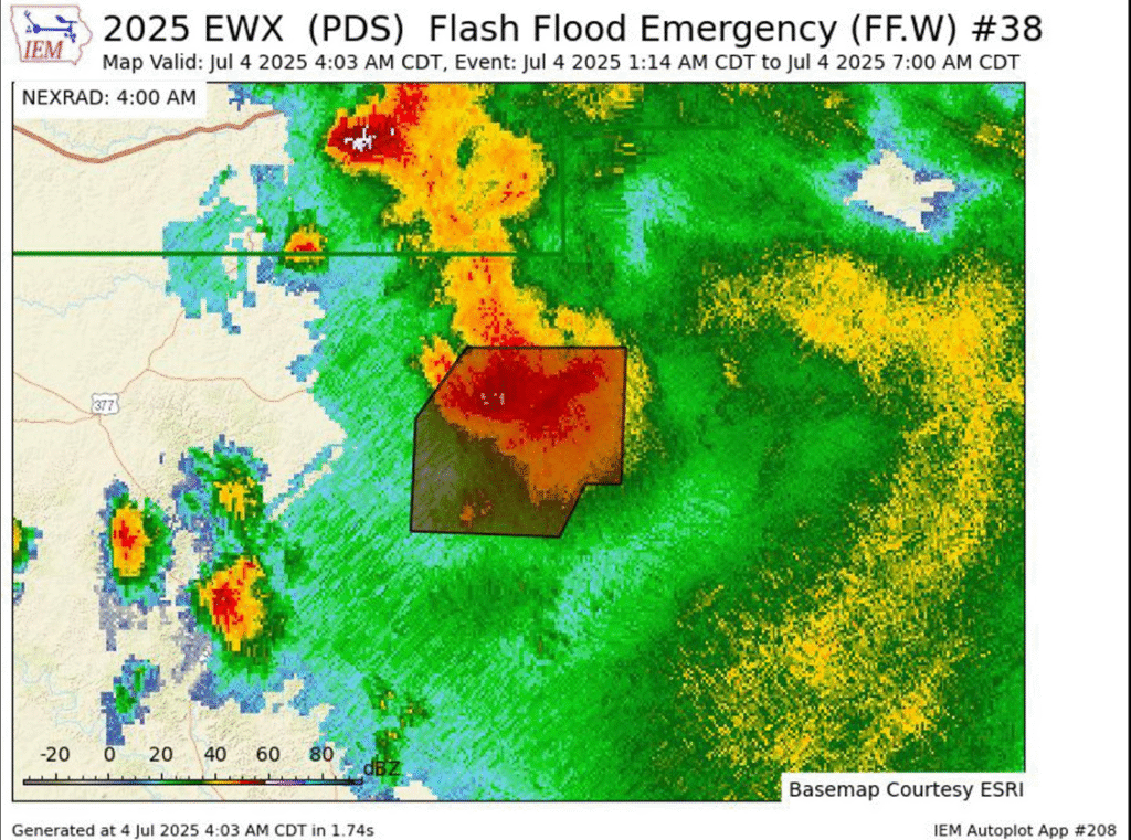
4:03 a.m. - Flash Flood Emergency Declared
This is the most severe flood warning the NWS can issue. It is reserved for situations catastrophic and deadlyThe rainfall warning system represents the highest level of the extreme rainfall warning system.
4:20 a.m. - Guadalupe River reaches major flood level
At the Hunt (Texas), the Guadalupe River exceeds 22 feetentering a higher flood level.
15 minutes later, at 4:35 a.m., level reaches 29.45 feet (≈ 9 meters): one flood over 7 feet (2 meters) in less than 20 minutes. This sudden rise trapped dozens of people, including children in summer camps.
What went wrong?
- The alert system worked technically: there was more than 12 hours' advance notice.
- However, the rapidity of the event and possibly the lack of cellular coverage in rural areas affected response capacity.
- Many testimonials report that water arrived in a matter of minuteswith no time to evacuate.
Conclusion
The July 4 tragedy in Texas demonstrates how, even with a modern, functioning weather system, there are physical and social limitations that may prevent warnings from reaching everyone. Interagency coordination, effective communication, and community planning will be key to reducing the impact of future extreme events.


