


Thanksgiving week is always tricky for travel, but this year the weather promises to add an extra challenge. From heavy rain in Texas to possible snow in New York and Minnesota, two storm systems could disrupt flights, roads and travel on some of the busiest days of the year. For Latino families traveling to join their loved ones, understanding which days will be most challenging and which areas will be most at risk is key to avoiding delays, cancellations or dangerous situations on the road.
Important points
- Storms Sunday 24 to Monday 25: heavy rains and flood risk in Texas and the South
- Which routes and airports will be most affected?
- Planned accruals
- Useful tip if you are traveling by road
- Tuesday 26: Bad weather moves into the southeastern US.
- Airports at risk of delays
- Implications for the Latino community
- Wednesday 27: rain in the northeast and a chance of snow in Minnesota
- What does it mean for travelers?
- Wednesday's most sensitive air routes
- Thursday 28th: a mostly dry Thanksgiving, but with unknowns in the Northeast
- Key points
- After Thursday: arctic air arrives and a turn toward winter
- What to expect?
- Will this pattern last?
- How to prepare if you are traveling this week
- For flights
- For road
- For those traveling with family
- Canal Meteo's role in this week's travels
The models agree on two ideas: first, that between Sunday and Wednesday there will be a marked increase in showers, thunderstorms and possible flash flooding; second, that just after the holiday an arctic air mass pushed by a polar vortex disturbance could plunge over much of the country, bringing an early turn toward wintry conditions.
Here we break down, day by day, what you need to know and how to prepare, especially if you are part of the 82 million people expected to travel to the United States this week.
Storms Sunday 24 to Monday 25: heavy rains and flood risk in Texas and the South
The first system starts on sunday night, The storm will move from the southwest into the central and southern portions of the country. Most significant will be heavy rain over Texas, Oklahoma, Arkansas and Mississippi.
The authorities have already indicated flood risk levels of 2 over 4, especially in urban and rural areas that have not yet recovered from the recent floods.
Which routes and airports will be most affected?
Cities that could see major problems include:
- Dallas-Fort Worth (DFW)
- Austin (AUS)
- Houston (IAH/HOU)
- Oklahoma City (OKC)
- Little Rock (LIT)
If you are traveling on Monday morning, be prepared for:
- Flight delays.
- Extra congestion at airport accesses.
- Roads with deep puddles and poor visibility.
Planned accruals
Central and North Texas could be hit 3 to 5 inches of rain between Sunday and Tuesday. Areas that have had recent soil saturation have an even greater risk of flash floods.
Useful tip if you are traveling by road
Avoid the early hours of Monday. The heaviest rain will coincide with rush hour and complicate intercity routes such as I-35, I-20 and I-45.

Tuesday 26: Bad weather moves into the southeastern US.
By Tuesday, the main system will exit Texas and intensify over the southeast.
Cities such as Atlanta, Charlotte, Nashville y Birmingham will see persistent showers and even local thunderstorms.
Airports at risk of delays
- ATL (Atlanta) - the busiest in the world.
- CLT (Charlotte) - a critical hub on the east coast.
- BNA (Nashville)
- RDU (Raleigh-Durham)
Even moderate delays in Atlanta or Charlotte can generate a domino effect on flights to the Northeast, Texas or Florida.
Implications for the Latino community
The Southeast has a growing Hispanic population that often travels by road to join family members. Keep in mind:
- Stretches of persistent rain for many hours.
- Limited visibility on Appalachian mountain routes.
- Increased risk of hydroplaning on I-75, I-85 and I-95.
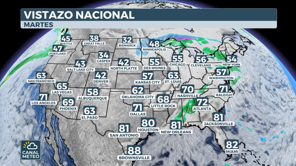
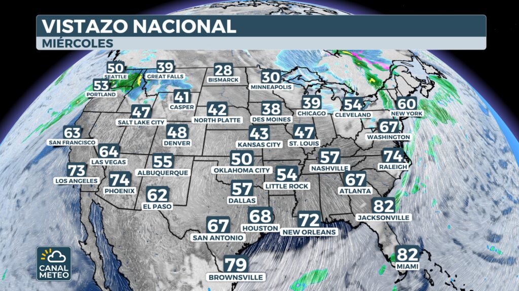
Wednesday 27: rain in the northeast and a chance of snow in Minnesota
Wednesday is the key day:
a new cold front will cross the northern fringe of the country, carrying rain to the northeast y snow to parts of Minnesota, the Dakotas and Wyoming.
What does it mean for travelers?
- At Minneapolis (MSP) it could snow, and any freezing precipitation on Thanksgiving eve usually results in cancellations.
- In the Northeast (New York, Boston, Philadelphia), The rains could saturate airports already overloaded by holiday traffic.
- Gusty winds will worsen the scenario in mid-Atlantic cities and New England.
Wednesday's most sensitive air routes
- NYC (LGA/JFK/EWR)
- Boston (BOS)
- Philadelphia (PHL)
- Washington D.C. (DCA/IAD)
- Baltimore (BWI)
Any delays in New York are amplified to the entire country, but especially to flights to Florida, Texas and California, traditional destinations for the Latino community at this time of year.
Thursday 28th: a mostly dry Thanksgiving, but with unknowns in the Northeast
The good news: much of the country will be dry on Thanksgiving Day.
The bad: models still disagree on a possible rain or snow event that could brush the Northeast, including the tri-state area.
Key points:
- If it materializes, it could affect the Macy's Parade in New York.
- It would be a fast system, but enough to complicate morning transfers.
- The most sensitive areas would be New York, Connecticut and Massachusetts.
For now, the recommendation is to check the local forecast. 24 hours before.

After Thursday: arctic air arrives and a turn toward winter
After the holiday, extreme cold will be the protagonist.
A change in the structure of the Polar Vortex will allow arctic air to move into the central and eastern part of the country between Friday and Saturday.
What to expect?
- Temperatures in the teens in the Upper Midwest.
- Wind chill much lower due to wind.
- Thermal lows in the Appalachians, East Coast and part of the Southeast.
- Possible early frosts in southern states.
Will this pattern last?
Meteorologists point out that this could be the start of a more consistent winter pattern just as the arrival of the winter weather (December 1).
How to prepare if you are traveling this week
Here are some essential recommendations if you are one of the millions who will be traveling:
For flights
- Check the flight status before going to the airport.
- Avoid stopovers in cities with bad weather if you can still change itinerary.
- It has an external battery and notifications activated.
For road
- Drive slower during heavy rains.
- Check tires before leaving.
- Avoid roads next to rivers or areas prone to flooding.
- Carry extra water, water bottle and extra clothes if you cross cold areas.
For those traveling with family
- Carry unloaded entertainment for airport delays.
- Secure child seats correctly.
- Start the trip earlier to avoid peak hours of bad weather.
Canal Meteo's role in this week's travels
In such a dynamic week, the clear information in Spanish is key.
In Canal Meteo we offer:
- Updated forecast by region.
- Real-time weather alerts.
- Simple explanations of travel risks.
- Videos and fast transmissions when conditions change.
Our goal is for the Latino community to travel informed and safe, especially when weather can cause scares, delays and complications.
Remember that you can find us at our app for iphone, android and also on Roku.


