Storms and flooding in California
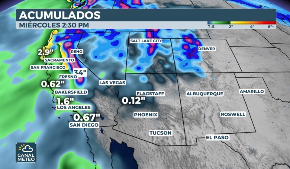
The West Coast of the United States begins the year with a very active weather pattern. Several consecutive storms are affecting California and the Pacific Northwest. The result is heavy rain, strong winds, snow on mountains and risk of flash floods during the weekend.
Heavy rains from north to south
As of Friday, precipitation will extend from the Northern California to Oregon. The heaviest rains will begin on Saturday morning and will continue on Sunday, especially in the central and southern California.
The authorities warn of possible flooding in coastal areas as well as in urban and mountainous areas.

Risk of flooding for several days
The National Weather Service maintains an active flood risk level 1 out of 4 coast of California through Monday.
In addition, there are zones with risk level 2 out of 4 in the north and south of the state, including areas close to Los Angeles and mountainous regions.
High tides and coastal risk
In the area of San Francisco Bay, a warning has been issued for coastal flooding due to the combination of neap tides and storm surge associated with the storm.
The following are expected floods up to 75 centimeters, The levels have not been recorded since the end of the 1990s.

High wind and dangerous conditions
The gusty winds will be another key factor. Much of the California coastline has active warnings, with gusts that could exceed 70 km/h. These conditions can lead to downed trees and power outages.
Abundant snow in the Sierra Nevada
In the Sierra Nevada, above the 1,500 meters, accumulations of 60 to 120 centimeters of snow, with larger amounts at higher elevations.
A winter storm warning will remain in effect until Monday.
The combination of snow and wind can lead to extremely dangerous travel conditions on mountain roads.

Isolated thunderstorms
Between Saturday and Sunday morning, the following could be recorded thunderstorms in northern California and Oregon. Severe risk is low, but monitoring is ongoing. strong gusts of wind and isolated phenomena.
A pattern that could continue
Following New Year's Day flooding in Southern California, the outlook remains unstable.
Looking ahead to next week, the active pattern could be maintained, with more rain, mountain snow and wind, prolonging this episode of adverse weather.
How to watch weather channel? here you have all our platforms