The responsible system is a clipper. This is a fast-moving low pressure that descends from Canada. This type of system crosses the Great Lakes before turning eastward.
This time, the clipper will cross New York and New England between Friday and Saturday. Accumulations will be light in most areas. However, gusty winds will complicate road travel.
This episode comes on the heels of a recent historical storm which left double-digit snowfalls. Therefore, the region accumulates a notable surplus with respect to its winter average.
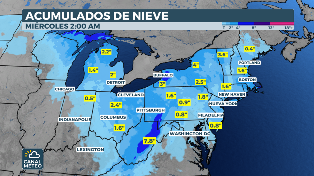
How much snow will the northeastern U.S. accumulate by city?
Accumulations vary according to the area. New York could add between 1 to 5″ extra. In contrast, Philadelphia and Albany will receive up to 2″.
The mountains of West Virginia expect the highest figures. There they could drop between 10″. In fact, winter storm watches are already in place for those high elevations.
On the other hand, Boston and the Massachusetts coast could accumulate to 5″. The ocean effect will enhance coastal snowfall through Saturday afternoon.
Historic surplus: northeast U.S. snowpack hits records
Northeast U.S. snow falls over an area with exceptional numbers. Areas downwind of the Great Lakes record between 110 % and 200 % of their seasonal average. Thus, each new episode adds pressure on infrastructure.
Cleanup services have been working around the clock for weeks. Salt and sand reserves are in short supply in several counties. This excess snow also increases the risk of flooding during the spring thaw.
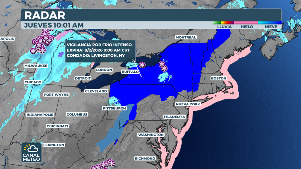
High winds and heavy snow showers
The system will reach the Atlantic on Sunday. It will organize itself as a coastal cyclone before moving offshore. At the same time, a strong high pressure to the west will strengthen the barometric gradient.
As a result, the following are expected 40 mph gusts over much of the northeast. These winds will reduce visibility due to drifting snow. Heavy showers with rapid accumulations could also occur.
Areas with higher risk of showers
The most exposed areas include upstate New York and western Pennsylvania. Similarly, inland New England is at elevated risk. Visibility can drop to near zero in a matter of minutes.
For this reason, extreme caution should be exercised on the roads. Travel between Friday night and early Saturday morning will be the most dangerous.
Polar irruption: the coldest cold of the season
The cold accompanying this system will be exceptional. This will be the most powerful polar blow of the entire winter. The thermal sensations could drop as low as -15 °F in some localities.
Strong winds from the northwest will channel air from the polar vortex. Boston, New York and Philadelphia will experience the harshest conditions. The National Weather Service may issue severe weather warnings. extreme cold, which is very rare in this region.
Northeastern U.S. Snow and Extreme Cold Recommendations
In these temperatures, exposed skin can freeze in just a few minutes. Therefore, taking precautions before leaving home is essential.
Tips to protect yourself from the cold
Layering and covering the extremities is a priority.. Gloves, hats and scarves are essential. It is also advisable to limit outdoor activities to the minimum necessary.
The elderly and children are especially vulnerable. Those who must go out should reduce exposure time as much as possible. In addition, checking the heating system at home is a good precaution.
Precautions on the road
Drivers should check road conditions before traveling. Carrying blankets, water and a charger in the vehicle can be vital. In case of emergency, staying inside the car with the engine running is the safest option.
In short, the snow northeast USA. and extreme cold demand maximum caution this weekend. From Weather Channel We will continue to report on the evolution of this weather situation.