Six states under winter storm watch. The Carolinas and Virginia are bracing for 8-12 inches of snow, 70 mph winds and storm surge.
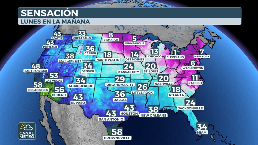
A powerful nor'easter threatens the East Coast of the United States this weekend. The system has the potential to become a bomb cyclone. The Carolinas and Virginia will be hardest hit by this winter event. This nor'easter comes just days after another massive storm. That storm traveled more than 2,300 miles across the country. It left dangerous ice and heavy snowfall in several regions. At least 60 people have died in 16 states. Weather models show high confidence in this system. It is virtually certain to impact the Carolinas and Virginia. However, the exact path to the northeast is still uncertain.
North Carolina Governor Josh Stein declared a state of emergency. The State Emergency Response Team is now activated. They will assist affected communities with needed resources.
«I urge everyone to stay alert and take precautions in the face of this new round of winter weather.»
- Josh Stein, Governor of North Carolina
⚠ States under Winter Storm Watch.
What is a nor'easter and how is it formed?
A nor'easter is a storm that develops along the East Coast. It is characterized by strong northeasterly winds. These winds can exceed 60-70 mph in intense cases. The Polar Vortex will send cold air from Canada this week. This air will spread over the Great Lakes. It will eventually reach the southeastern part of the country.
A low pressure will form off the southeast coast. It will develop over the warm waters of the Gulf Stream. The contrast between the cold air and warm water will intensify the storm. As the low strengthens on Saturday, it will pull moisture northward. At the same time, it will keep cold air trapped inland. This will promote a prolonged period of snow.
What is explosive cyclogenesis?
This nor'easter has a high potential for rapid intensification. This is called explosive cyclogenesis or bombogenesis. It is also known as a «bomb cyclone». Explosive cyclogenesis occurs when the central pressure drops 24 millibars in 24 hours. Current projections are impressive. The system could drop from 1,005 mb to 967 mb between Saturday afternoon and midday Sunday. That level of strengthening creates a very tight pressure gradient. The result is powerful winds and extreme conditions. The Outer Banks will face the most dangerous conditions.
Expected impacts in the Carolinas and Virginia
Friday: Start of the event
Snow will begin during Friday afternoon. The system will develop first in the Tennessee Valley. Impacts will be minimal initially. Nashville, Gatlinburg and parts of Virginia could see light snow. This phase is just a prelude to the main event.
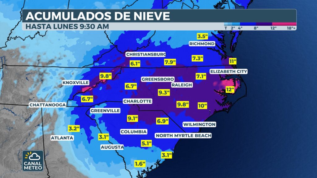
Saturday: Highest impact day
Saturday morning the situation will change rapidly. The coastal low will begin to develop. Snow will spread across the high elevations of several states. The most affected cities will be Richmond, Raleigh, Charlotte and Columbia. Accumulation rates could be very high. Very few breaks are expected throughout the day.
If everything comes together correctly, Raleigh could see one of its five largest snow events in history.
Snow will capture media attention. However, the most serious impacts will be on the coast. The combination of factors is worrisome. Gusts of 60-70 mph will arrive from the sea. The surge will be high and cause significant erosion. The scenes could be reminiscent of hurricane season impacts. The system will pass very close to the coast. This will allow for near hurricane force gusts. Some coastal locations could lose additional homes.
✓ Safety recommendations
Supply food and water for 3-5 days.
Fully charge electronic devices
Have flashlights and batteries available
Avoid traveling on Saturday and Sunday
Move away from coastal areas if possible.
Follow the instructions of local authorities
This nor'easter poses a serious threat to millions of people. The Carolinas and Virginia will face dangerous conditions. Proper preparation is essential. Weather Channel will continue to monitor this system around the clock. We will provide constant updates. Stay informed and take the necessary precautions. For more information on how to prepare for winter storms, visit our complete guide. You can also consult the active NWS alerts for your area.