

A widespread winter storm will affect the United States midweek. The system will bring snow to lake effect regions and the Appalachians, while the East Coast will be mostly rained out. At least 25 states will be impacted by this new winter episode. Snow will arrive as far south as Tennessee and North Carolina, and will again focus on the classic lake effect areas of the Midwest and the interior Northeast.
A fast clipper activates the winter pattern
The event starts on Tuesday, with the advancement of a system type clipper through the Great Lakes. These systems are characterized by their speed and by generating abrupt time changes. After the passage of the clipper, a cold front will become the main driver of precipitation. Behind it, the colder air will allow the appearance of snow showers in several regions. The Ohio Valley, including West Virginia, In the early stages of the event, light snow could be seen.
Lake Michigan, at the center of the impact
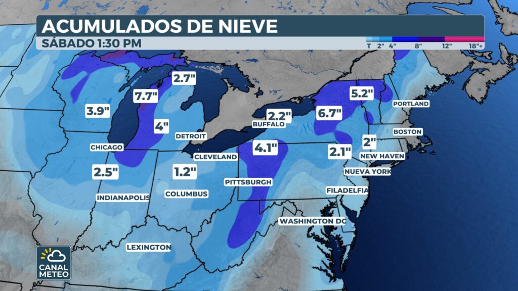
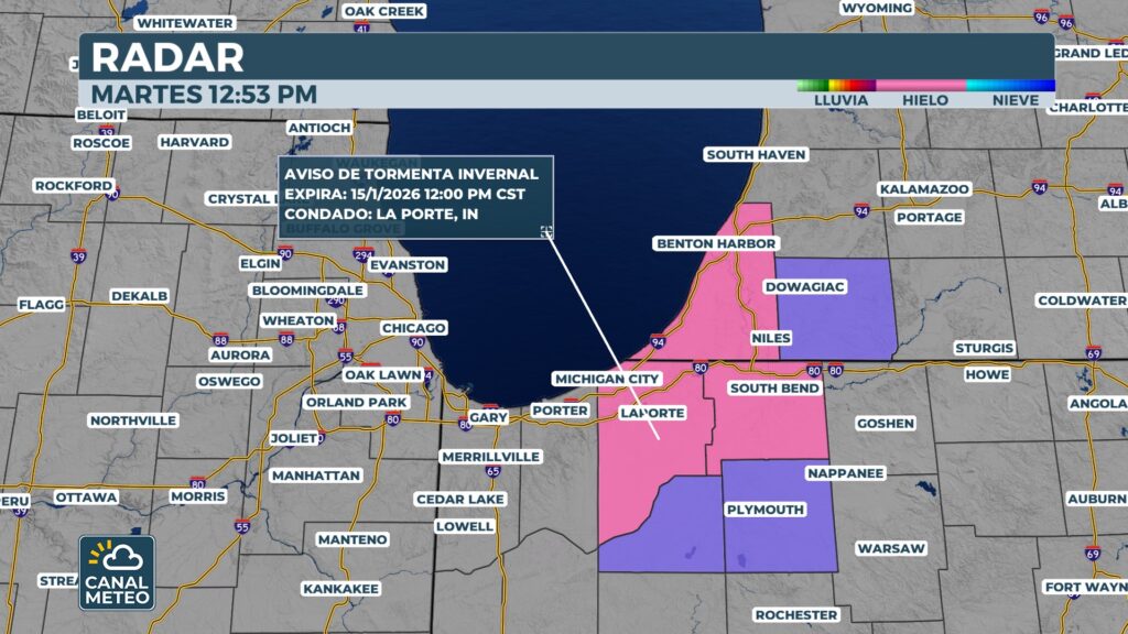
The snow of lake effect will focus mainly on the Lake Michigan. Conditions are favorable for significant accumulations Wednesday through Thursday. Parts of northern Indiana are already under winter storm watch, especially in areas near the southern shore of the lake. Accumulations could be between 20 and 30 centimeters (8 to 12 inches) in the most affected areas. Everything will depend on the final wind direction, a key factor in this type of snowfall.
More rain than snow on the East Coast
Although a more extensive snowstorm was initially expected, the scenario has changed. Prior to the arrival of the cold air, a warmer air intake will transform much of the precipitation into rain. This will cause the East Coast experience mainly rain on Wednesday, The risk of snow accumulations is significantly reduced. The corridor of the I-95 will see minimal impacts. Even so, brief snow episodes could result in occasional visibility problems, especially during rapid air mass changes.
Appalachia to see snow again at higher elevations
By late Wednesday, the storm will move toward the Appalachia. The cold air entering from behind the system will favor snow due to orographic ascent. The most consistent accumulations are expected in the higher altitude areas, from the border between Tennessee and North Carolina to the north of West Virginia. Outside of these elevated areas, temperatures will be too warm for widespread snowfall. To the west of the mountains, light snow may fall. To the east, light to mixed rain is most likely.
Other lakes also under surveillance
In addition to the Lake Michigan, Lake effect snow is expected around:
- Lake Superior, near Marquette
- Lake Erie
- Lake Ontario
- Northern Pennsylvania
- New York State Interior
Small changes in the wind can significantly modify the areas with the highest accumulations.
Conclusion: broad, but very localized impact
This is not a major snowstorm on a national scale. However, the impact will be large and unequal. Lake effect areas and mountains will be the most affected. Low lying areas and the East Coast will be dominated by rain. As always in these types of patterns, details are everything. Wind and temperature development will make the difference between a notable snowfall or limited impact.
Remember as you can see canalmeteo