A potentially catastrophic winter storm threatens more than 35 states in the United States. More than 175 million people are in the path of this massive system. The storm will extend more than 2,000 miles beginning Friday.
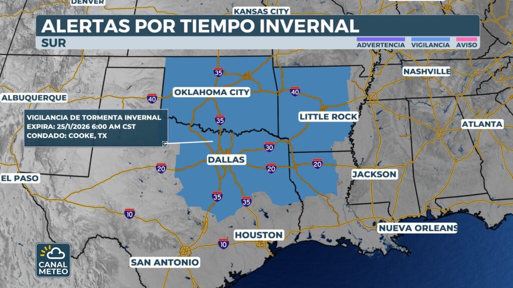
Winter Storm Watches have expanded across the country. The reach of this system will be immense. Snow and ice will extend from the Southwest to the Mid-Atlantic coast.
South Carolina and North Carolina have declared states of emergency. This measure prepares the states for the approaching winter storm. Response resources are already being mobilized.
The state of emergency activates the South Carolina Emergency Operations Plan. This allows state agencies to mobilize resources quickly. The National Guard can activate personnel and prepare equipment.
Texas mobilizes state resources
Texas has activated its state emergency response resources. Governor Greg Abbott assured that this will ensure critical resources. Municipalities will be prepared in advance of any potential winter weather impacts.
Massive storm outreach
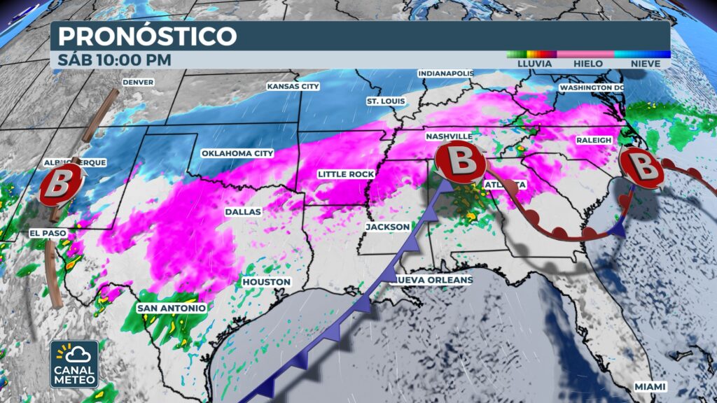
A broad swath of wintry weather will sweep across the country over the weekend. It will move from the Southwest across Texas and Oklahoma. It will cross the South and Tennessee Valley before reaching the Mid-Atlantic coast.
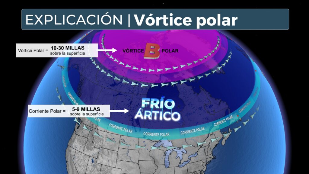
Behind the storm itself, arctic temperatures could freeze the snow and ice. This could create long-term power outages. Travel could be paralyzed for days at a time.
Post-storm conditions will be as dangerous as the event itself. Extreme arctic air will impede thawing. Power restoration operations will face significant challenges.
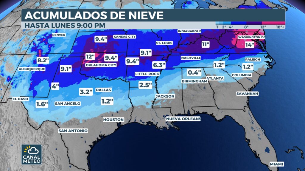
A key question that remains is how far north this storm will track. Any changes in the track will determine which states will see potentially record snowfall. It will also determine where dangerous ice will fall.
Those living along the Interstate 40 and Interstate 20 corridors should prepare. Significant wintry weather days will begin on Friday. Conditions will persist through the weekend.
Airports along those corridors will likely see days of significant cancellations. Delays will affect thousands of flights. Travelers should check the status of their flights constantly.
See the National Weather Service for updated alerts.
Ice storm
A crippling ice storm will be the primary threat within the southern component of this colossal system. More than 15 states stretch along a massive corridor from New Mexico to the Carolinas. Ice accumulation could cause numerous power outages Friday through Monday.
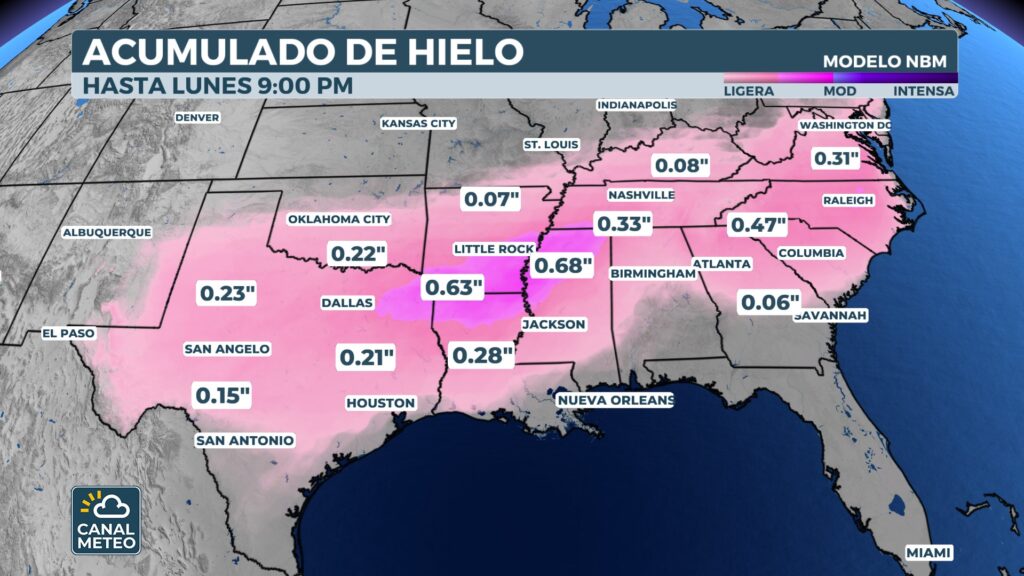
The focal point for the most significant ice accumulation is currently forecast from eastern Texas to southern Arkansas. This accumulation is capable of causing widespread power outages. Communities should prepare for prolonged loss of power.
The Dallas-Fort Worth metropolitan area should also prepare for dangerous ice beginning Friday. Roads will quickly become impassable. Residents should avoid unnecessary travel.
Another significant ice threat is forecast to develop on the eastern side of the Appalachians. It currently includes Atlanta, Augusta in Georgia, and Charlotte in North Carolina. These cities rarely experience ice events of this magnitude.
Areas from Atlanta to Columbia to Raleigh could see a half-inch of dangerous ice accumulation. This amount is enough to bring down power lines. Trees could collapse under the weight of the ice.
For more about ice storms and their dangers, visit our educational center.
Cold rain will break out from Dallas to Little Rock, Arkansas Friday afternoon. It will then transition to a dangerous wintry mix by Friday night. The change will be rapid and dangerous.
There is still some uncertainty from forecast models as to exactly where the snow-ice-rain lines will set up. However, there is strong agreement that the worst of the snow will remain north of the I-20 corridor.
Detailed chronology of the event
Friday: Storm exits the Southwest. Texas and Oklahoma begin to experience wintry weather. Rain transitions to wintry mix for the night.
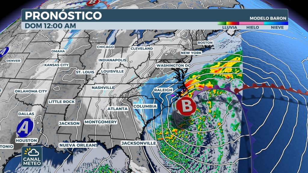
Saturday: System reaches the Southeast. Georgia and the Carolinas face dangerous ice. Virginia and DC begin to see snow overnight.
Sunday: Heavy snow continues in the Mid-Atlantic. Potential intensification near the East Coast. New York could see significant snowfall.
Monday: Final phase of the storm. Total accumulations determined. Arctic temperatures freeze snow and ice in place.
Conclusion
This potentially historic winter storm poses a serious threat to 175 million Americans. More than 35 states will face dangerous snow, crippling ice or both. Proper preparation now can save lives and reduce suffering.
Do not underestimate the severity of this weather event. Arctic temperatures will persist long after the storm ends. Impacts will last for days or even weeks in some areas.
Canal Meteo will continue to provide 24-hour updates as this historic system develops. Our team of expert meteorologists will monitor every aspect of this dangerous storm. Stay tuned for the latest alerts and forecasts that could save your life.
Follow the live webcast at weather channel.