A major winter storm will hit the southern United States this weekend. Millions of people will face dangerous snow and ice. The system will affect from Texas to the Southeast coast.
The first winter weather warnings are now active. They include portions of Texas, Oklahoma and Arkansas. The warnings will be in effect Friday night through Saturday.
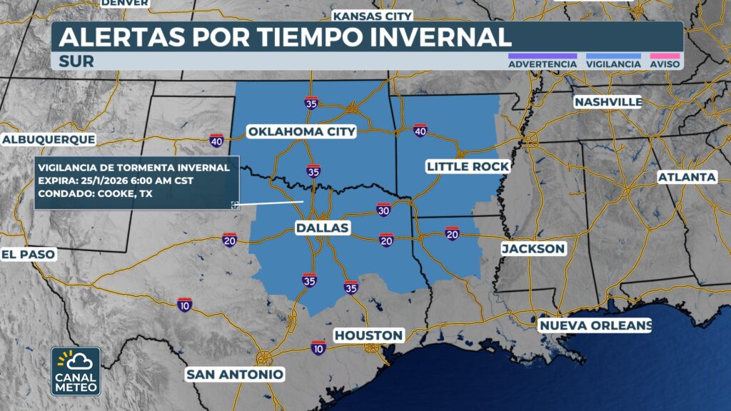
The authorities have issued Winter Weather Watches. Heavy accumulations of snow and ice are possible. Residents should prepare in advance.
Texas has activated its state emergency response resources. The Governor Greg Abbott made this preemptive decision. The objective is to ensure that Texans have the necessary resources.
«Temperatures could drop below freezing,» Abbott stated. «Regions of Texas will face snow, ice and freezing rain.» He urged residents to stay informed about the weather.
For information on winter storm preparedness, Please consult our specialized guide.
Activation allows the state to mobilize additional resources. Teams will be ready to respond to weather-related emergencies. This preventive measure will protect vulnerable communities.
Where will the snow and ice fall?
The exact location of snow, ice and rain remains uncertain. Details will become clearer as the weekend approaches. Meteorologists are constantly monitoring forecast models.
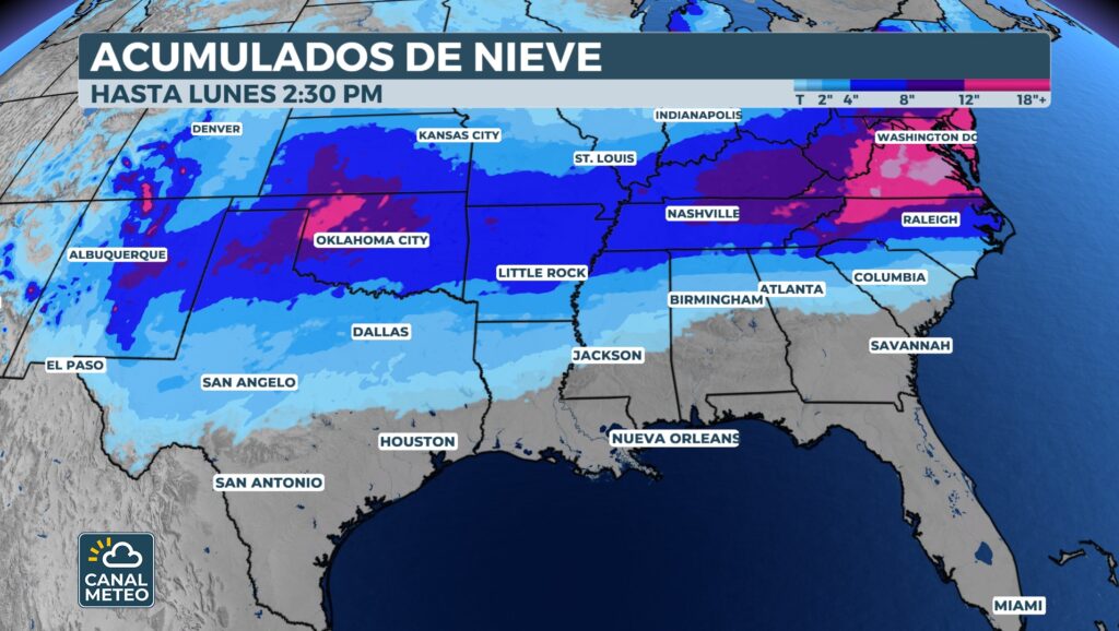
A system from the southwest will take advantage of widespread cold air. This cold air will dominate much of the country this week. The combination will create perfect conditions for severe winter weather.
Parts of Florida, Alabama, and Georgia saw rare snow accumulation over the past weekend. Some areas of the Florida Panhandle experienced snow in consecutive winter seasons. This was the first time this phenomenon had occurred.
See the National Weather Service for up-to-date alerts in your area.
The system driving the potential wintry weather will move in from the southwest. It will arrive on Friday or during the weekend. Its path will determine specific impacts.
The southern track of this storm will draw moisture from the Gulf of Mexico. This will create the potential for significant snow and ice. The combination of moisture and cold air is dangerous.
For more information about ice storms and their dangers, visit our educational article.
Potential Impacts of the Storm
The exact impact of the system will depend on its path. It will also be influenced by the amount of cold air present. These details will become clearer later this week.
Three Possible Scenarios
Meteorological experts identify several general possible outcomes. Each scenario has different implications for communities.
North Zone: Snow will likely develop north of the system's path. Accumulations could be significant in these areas.
South Zone: Rain will fall south of the main path. These areas will avoid the worst winter impacts.
Central Zone: A potentially impactful zone of ice will be established between the two. This is the most dangerous situation for residents.
Increased threat of ice
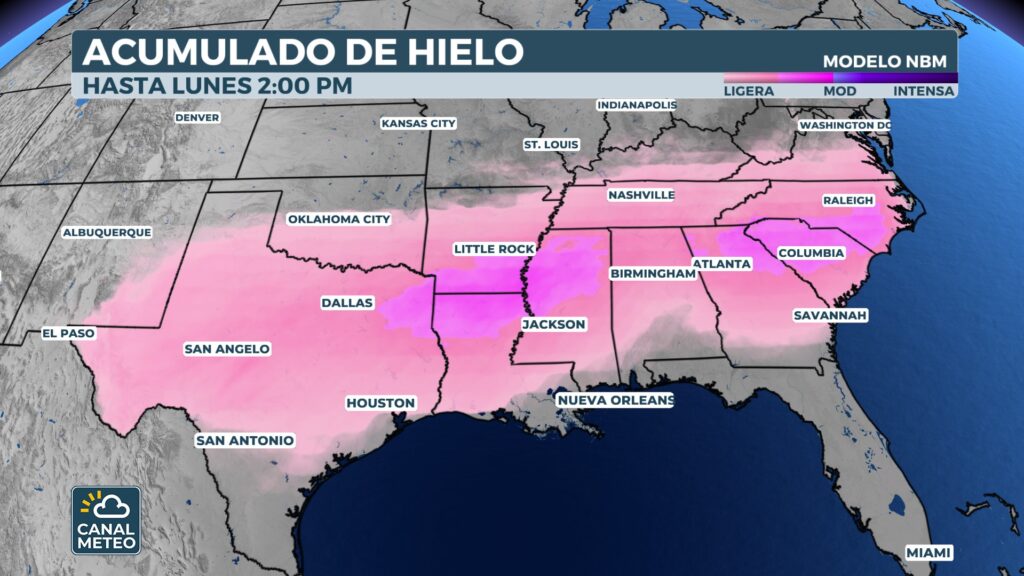
Currently, the corridor with the greatest ice threat includes an extensive area. It extends from central Texas eastward. It crosses the valleys of the Lower Mississippi and Tennessee. It continues into the Carolinas.
What are ice storms?
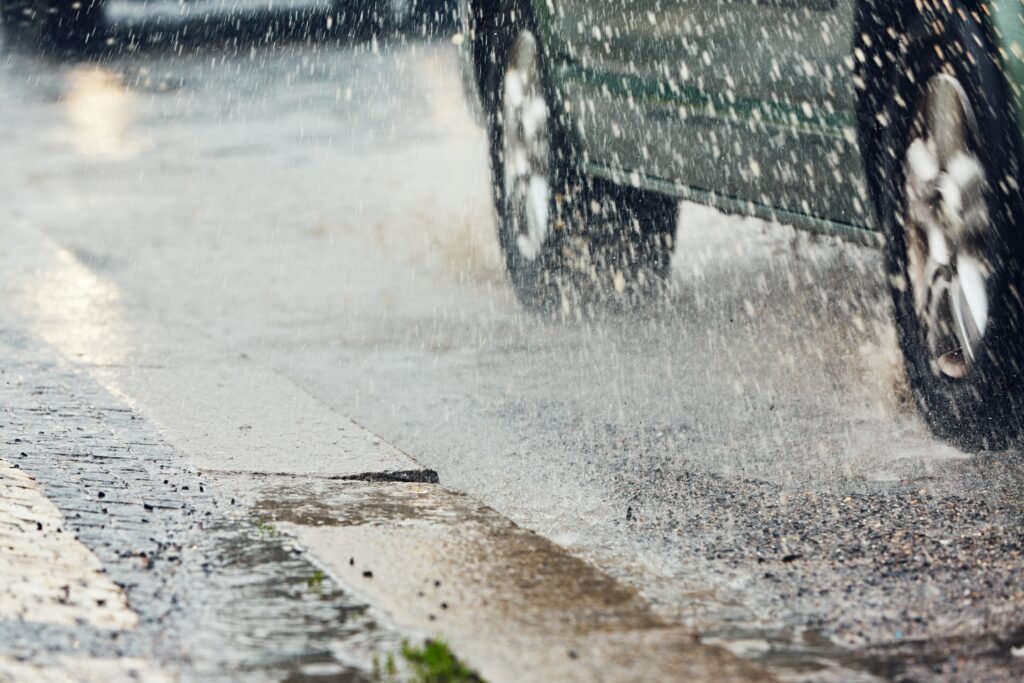
Ice storms occur when freezing rain accumulates. This layer of ice covers surfaces and creates extremely dangerous conditions. Trees and power lines can collapse under the weight.
Travel becomes nearly impossible during ice storms. Roads become skating rinks. Vehicle accidents increase dramatically during these events.
Learn more in the National Oceanic and Atmospheric Administration on winter safety.
Conclusion
This major winter storm will bring dangerous conditions to the southern United States. Millions of people from Texas to the Carolinas should prepare. Snow and ice will create potentially deadly situations.
Stay informed about changing conditions. Follow the recommendations of local authorities. Proper preparation can save lives.
Show image
Canal Meteo will continue to monitor this dangerous system. We will provide constant updates as the situation evolves. Your safety is our top priority.
Visit our weather alert center for the latest updates on this historic winter storm.