Don't put away your winter coat just yet. A powerful cold front is sweeping across the northeastern and mid-Atlantic United States on Monday, sending temperatures plummeting below freezing and bringing light snow to several major cities. The snow in the Northeast this April confirms that the 2025-2026 winter season has not yet said its last word.
Parts of northern New York state already reported snowfall during Monday morning, while the National Weather Service (NWS) has issued frost and freeze alerts in areas where the growing season had already begun.
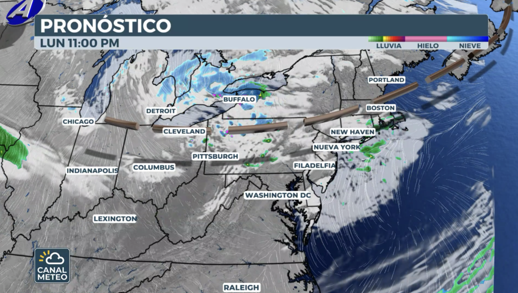
A fast clipper system is crossing the region
A fast-moving clipper system is sweeping across the Northeast, bringing light snow to major cities. According to NOAA's Weather Prediction Center (WPC), a compact wave that originated in Manitoba is shifting southeast, crossing the Great Lakes on Monday before tapping into the broader cyclonic flow over the Northeast by Tuesday.
Syracuse, New York, is already receiving April snow over the Northeast, and cities like Boston and Burlington, Vermont, could see a light dusting of snow into Tuesday. This late-season clipper shows that the tough 2025-2026 winter is not over yet.
How much snow is expected in the Northeast in April?
Although overall totals will be light, 1 to 3 inches of snow are expected, with slightly higher amounts near the Great Lakes and the higher elevations of the Adirondacks. The WPC notes that cold air advection in the wake of the system will push temperatures at 850 mb down to -15°C, creating an environment favorable for lake-effect snow in the snow belts northwest of the Great Lakes.
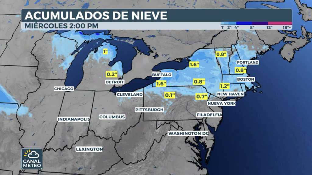
Cities in the snow's path include:
- Buffalo, NY
- Syracuse, NY: 1 to 3 inches
- Burlington, VT: about 1 inch
- Albany, NY
- Boston and New York: chance of isolated flurries
Most of these cities typically see their last measurable snow between early and mid-April, so this event, while late, is not unusual.
A winter that refuses to leave
This season has been a historic one for the Northeast. From cross-country storms to powerful blizzards, winter has kept the region trapped for months.
Providence, Rhode Island, broke its all-time record for the biggest snowstorm with over 37 inches of accumulation during the February blizzard. Multiple rounds of snow—some measured in feet—left records shattered and communities digging out for days.
The cold air will affect a wider area than the snow in the Northeast in April.
Although the late snow is notable, the approaching cold air surge will impact a much more extensive area. Just days after near-record temperatures, a 10 to 20 °F drop below average is expected from Monday through Wednesday.
Wednesday will likely be the coldest day, with wind chills remaining in the 20s across the Northeast interior. Low temperatures will drop to late-March levels in many locations.
When will the weather improve?
Light snow and below-average temperatures will persist from the Great Lakes to New England between Monday and Wednesday. However, a warming trend is expected by Thursday, with readings returning closer to seasonal averages.
This week's northeast April snowfall is not a severe event, but it does represent a reminder that the transition between winter and spring is rarely linear, especially after a season as intense as 2025-2026.